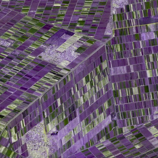
Khartoum, Sudan

80.00200.00

https://goo.gl/maps/z4SHJvuCqqs

  • 30 x 30 cm

    (12″ × 12″)

    80.00
  • 60 x 60 cm

    (24″ × 24″)

    120.00
  • 90 x 90 cm

    (36″ x 36″)

    160.00
  • 120 x 120 cm

    (48 × 48″)

    200.00
SKU: N/A
Categories: , , , ,

Product Description

Khartoum, Sudan
https://goo.gl/maps/z4SHJvuCqqs
.
Khartoum, Sudan

.
The image is of the farmlands just south of the Sudan, the country’s capital and second largest city. It sits between the White Nile River and the Blue Nile River, which flows west from Ethiopia. In this arid part of the country, much of the agriculture is highly concentrated around the rivers.
.
Every agricultural plot is a distinctive rectangle, with some substantially longer than others. This geometric arrangement allows each plot to be irrigated.
.
The main crops include sorghum, wheat, cotton, sunflower groundnuts, vegetables, fruit trees, and alfalfa.
.
#earthimages #earthimage #upintheair #abovetheclouds #satelliteimage #satelliteimages #EarthOverhead #overview #overvieweffect #khartoum #sudan #sorghum #wheat, cotton #sunflower #groundnuts #vegetables #fruittrees #alfalfa


Info

Dimensions N/A
Size

All images – except Platinum size – are shipped, rolled and tubed, on 250gsm photo­quality paper.
Platinum sized images [120cm x 120cm (4ft x 4ft)] are shipped, flat-packed, on durable rigid plastic Foamex (5mm thick) unless otherwise specified.

Shipping

Shipping via UPS or DHL

Border

All images are shipped to you with a clean, white border.
If you prefer to have no border, please add this to the “Notes” section on the payment page.

Color Variations

There may be a slight color variation between what you see on your screen and the final, printed image

Framing

Images are not framed